The City of Winnipeg has released a new set of plans for new bike lanes and pathways along Marion and Goulet St, St. Mary’s St, and Lagimodiere to kick off the 3rd phase of public engagement in the Moving on Marion Street project.
Based on what they heard about design options in Phase 2, they have created a proposed design that they believe will:
- Improve traffic flow and road safety
- Enhance neighbourhood vibrance and livability
- Add new active transportation infrastructure
The city would like you to review this proposed design to see what the Marion Street corridor could look like and how it would function. Most importantly, the city would like your feedback on the design and how it would change your experience with the area.
What they hear in this third phase will help them make decisions and refine the design with more technical detail.
Provide feedback online
View the proposed design and take the online survey(External link), which will be available until March 24, 2023.
Attend the open house
Learn more about the proposed design, ask questions, and provide feedback.
Date: Thursday, March 16, 2023
Time: 6:30 p.m. to 8:30 p.m.
Location: Norwood Community Centre, 87 Walmer St(External link).
Room: Large hall
Format: Drop-in (come and go)
No registration is required. Please join if you are able.
Bike Winnipeg’s Key Comments and Recommendations
While the design that has been brought forward has some needed improvements, there are still some key issues that we think need to be redesigned before we feel it will be construction ready.
- Realign the entrance to Lyndale Dr to create better connections from the Norwood Bridge to the Marion bike lane
- Improve access to the Red River pathway from the Norwood Bridge
- Upgrade the crossings at Enfield to a half signal crossing
- Ensure that a crossing of the CNR Sprague rail line is negotiated before any decision is made to to widen Lagimodiere or drop Lagimodiere from the planned bike network is finalized
- Show the planned Kenny Neighbourhood Greenway
- Fully connect the planned Archibald pathway to the Marion Pathway
- Ensure left turns are facilitated by adding queuing/stacking lanes
- Add connections to/from Braemar Ave
- Consider a detour around the Domo and Maple Leaf sites
Recommended Realignment of Lyndale Exit
Speeds and geoetry on the exit from St. Mary’s Rd/Queen Elizabeth Way to Lyndale Dr are a definite concern. Changes to Marion and the coming first phase of Rapid Transit along St. Mary’s Rd provide an opportunity to realign the exit onto Lyndale Dr to slow down exiting traffic and improve the safety of those using the pathway coming off of the Norwood Bridge.
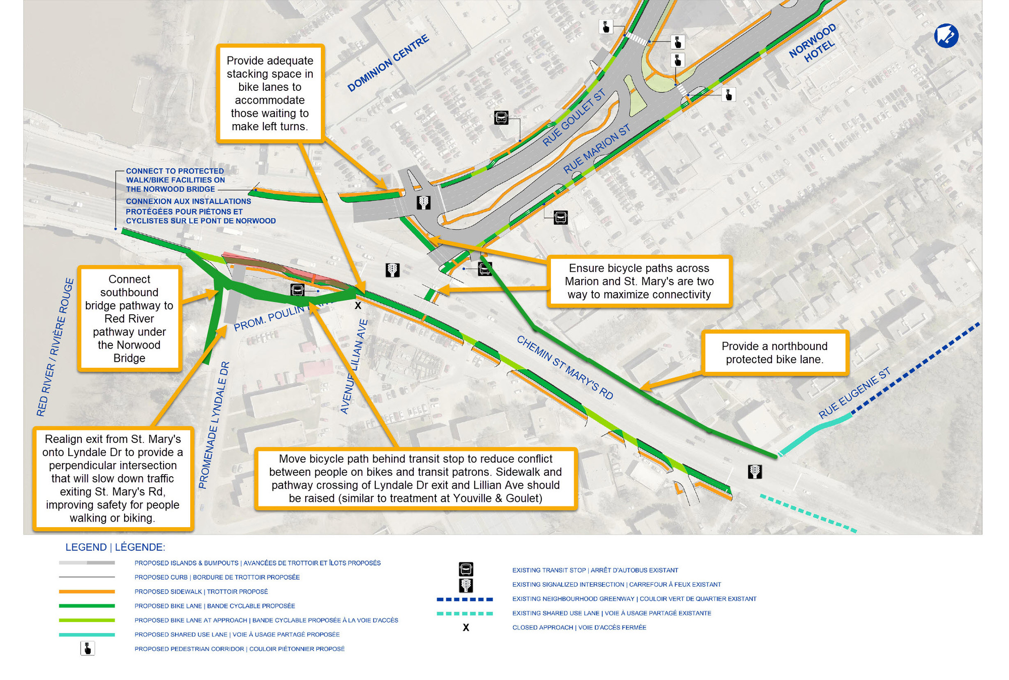
Redesign this intersection to slow down vehicles coming off of St. Mary’s onto Lyndale Dr.
- Push the entrance to Lyndale south approximately 15m to where it will intersect St. Mary’s road at a right angle.
- Realignment allows the crossing of the Lyndale Dr exit to offset from St. Mary’s as per best practice.
- We recommend a raised crossing to promote yielding behaviour.
- Lyndale is now 30k m/hr
- This would act as a physical reminder that you are entering a slower speed zone.
- This is similar to changes that have been proposed for the exits to/from Kingston Row being proposed as part of the St. Vital Bridge Rehabilitation Project.
A rapid transit station will be developed in the Lyndale-Poulin-St. Mary’s triangle within 5 years. We need to improve the safety of routes to and from that station.
- Even with the loss of 15m, there is still plenty of space (> 50m) to accommodate two 18.5m articulated buses
Consider pushing the bike lane/path behind the station and re-integrate it with the roadway south of Poulin @ St, Mary’s.
- This reduces conflict between transit passengers and people on bikes.
- It allows the two-way path coming off of the Norwood Bridge to be extended to Lilian and the crossing of St. Mary’s where people on bike can connect to the Marion protected bike lanes.
- This may require the loss of a short section of the northbound travel lane on Poulin Dr as it approaches Lilian to accommodate the bicycle path, but traffic counts on Poulin Dr are surely low enough to allow for a single lane access to provide two-way travel here. This would be no different than a chicane.
Norwood Bridge Pathway Connection to Marion
Realignment of the Lyndale Dr exit as described above would create space to extend the pathway coming off of the bridge to the pathway leading under the bridge to the Red River pathway, St. Boniface Hospital, and St. Boniface College.
Questions and concerns about a two-way path along St. Mary’s Rd
A two-way path is planned along the south side of St Mary;s Rd from the Norwood Bridge to Eugenie.
Two-way paths along two-way streets, especially busy streets such as St/ Mary’s, introduce a number of conflict points between people biking along the pathway and those driving motorized vehicles on the street. Conflicts between people making left turns off of the roadway and those biking in contraflow lane of the bike path, who are generally out of the line of sight of those drivers as they focus on oncoming traffic, and riding at a much higher speed than people walking on the sidewalk.
What is the risk of having a two-way bike lane on St. Mary’s Rd, and what is planned to mitigate the additional conflict points a two-way bike path adds?
- Is the access from NB St. Mary’s Rd onto Cromwell being closed?
- Is the access from NB St. Mary’s Rd into the Santa Lucia lot being maintained?
- What has been done to mitigate the threat from left hook collisions along the two-way St. Mary’s bike path?
- What is the offset distance of the bicycle path from southbound St. Mary’s?
- If a two-way path is developed, an offset of 5m plus raised crossings should be provided.
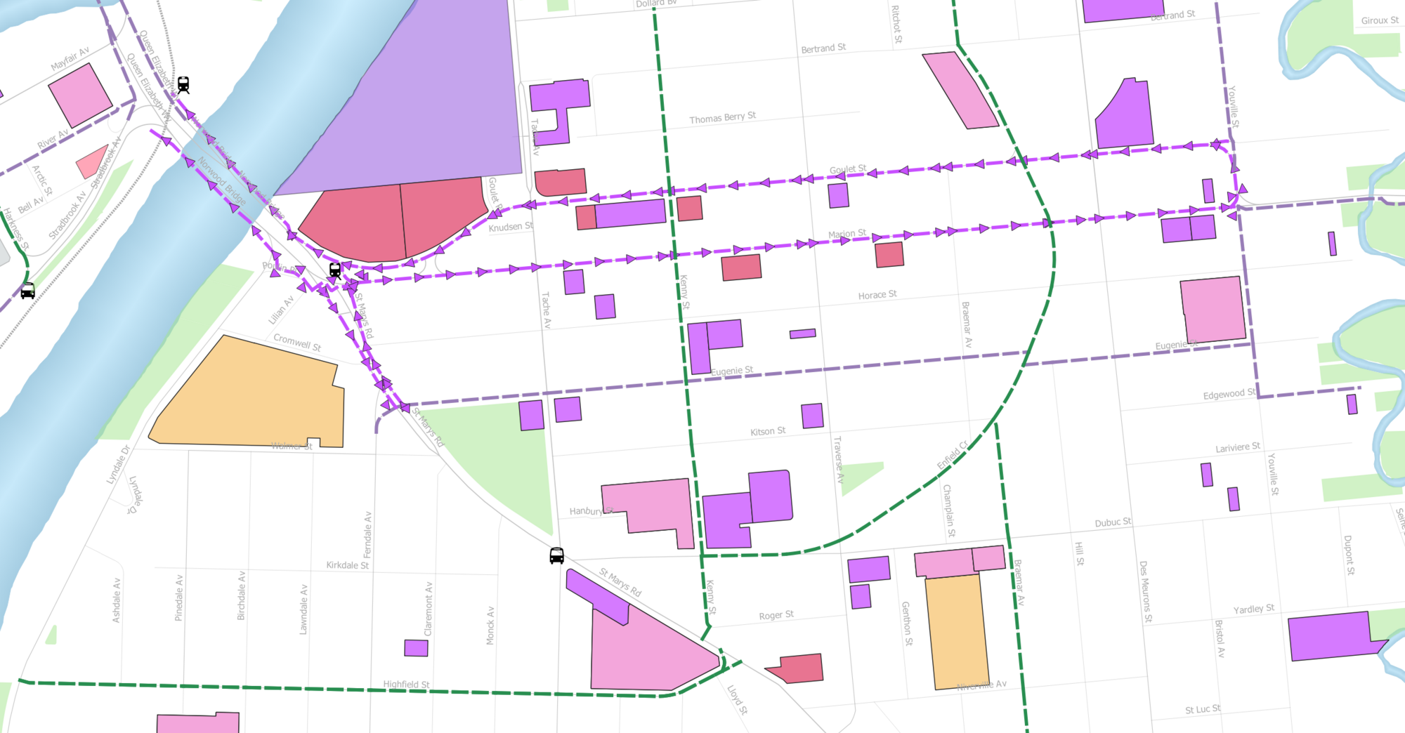
The following would seem to create almost all of the needed connections
- St Mary’s Rd
- two -way bike path on the west side of St. Mary’s Rd from Norwood Bridge to St. Mary’s Rd crosswalk @ Marion
- Route this along the west side of Poulin Dr and have it end at Lilian Ave.
- You may need to reduce Poulin Dr to one lane at the entry to Lilian, but traffic counts on Poulin Dr are lilley low enough to allow for a signal lane access to provide two-way travel here.
- Have we measured turning volumes?
- One way southbound from Lillian to Eugenie on the west side of St. Mary’s
- One way northbound from Eugenie to Marion on the east side of St. Mary’s
- This would follow the merge lane off of St. Mary’s onto Marion, where it would connect with two-way bike paths leading across Goulet via the Dominion Mall entrance and south across St. Mary’s to St. Mary’s @ Lilian where it would connect with the two-way portion of the St. Mary’s bike path.
- While it may be tough to get this extended all the way to Eugenie, it should be provided for as much length as is possible
- two -way bike path on the west side of St. Mary’s Rd from Norwood Bridge to St. Mary’s Rd crosswalk @ Marion
- Marion St
- One way eastbound on the south side of Marion between St. Mary’s Rd merge lane and Happyland Park
- Goulet St
- One way westbound on the north side of Marion/Goulet
- Two way bike path on the south side of the access out of Dominion Centre to Marion.
- Lilian Av
- Two way bike path across St. Mary’s Rd to connect up with the northbound St. Mary’s Rd bike lane, the two-way bike path between Dominion Centre and Marion St, and the one way eastbound bike lane on the south side of Marion
- There is space to add a stacking at Lilian and St. Mary’s Rd
The risks from a two-way bike path seem to outweigh the benefits.
- There are 5 crossings in 225m of pathway between Marion and Eugenie.
- Two Streets
- 3 Driveways
- 2 Left turn openings (Cromwell, Santa Lucia Pizza parking lot)
- The benefit of access on the southbound side of St. Mary’s is countered by the lack of a bike lane on the northbound side of St. Mary’s
- These challenges to a two-way bike lane run the full length of St. Mary’s
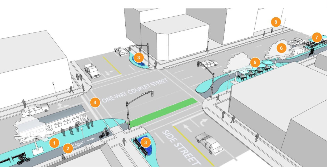
Protected Bike Lanes along Marion/Goulet Couplet
The complete street illustration provided on the 3rd board indicates that intersections are being designed as protected intersections, which we are happy to see.
Design of the bike protected lanes along Marion and Goulet will need to ensure that:
- Left turns from the protected bike lanes onto side streets are accommodated
- Include space for queue lanes where high rates of left turns might be expected
- Enfield Cr
- Braemar Ave
- Kenny St
Kenny St
Kenny St has been added to the proposed cycling network as a direct connection between Marion/Goulet and HIghfield St in the Norwood Flats neighbourhood. The Moving on Marion plans should reflect this. Kenny is a key connection. It has replaced Traverse in the 2021 proposed bike network.
Key Destinations along Kenny
- Options Pathways & Transitions
- École Précieux-Sang
- Sara Riel Inc.
- Precious Blood Parish
- Nelson McIntyre Collegiate
Enfield Crescent Crossing Concerns
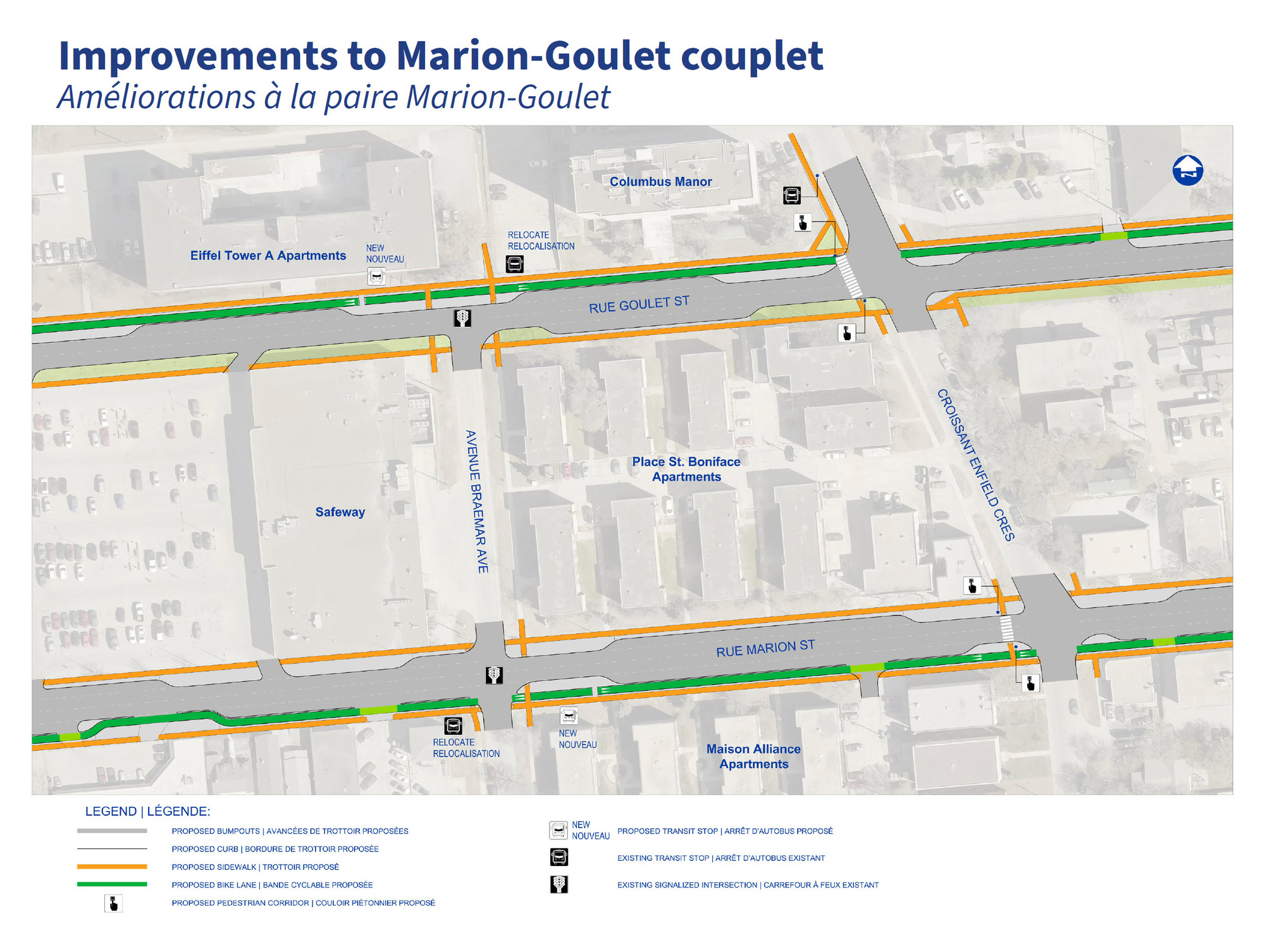
We do not feel that the pedestrian corridor crossing treatments proposed for the Enfield Cr crossings is adequate.
- How will the pedestrian corridors be activated by people biking along Enfield Cr?
- Where will people driving along Marion and Goulet stop when the pedestrian corridor is activated?
The pedestrian corridor on the Goulet crossing would seemingly stop cars in the line of people biking along Enfield Cr., and activating this crossing from a bike on the Enfield Cr roadway would be something new for Winnipeg.
A half signal would be less confusing and would likely encourage more people to ride along the roadway vs the sidewalk.
Access to/from Braemar Ave
While Braemar Ave is not part of the cycling network at this point,it would be nice to provide a connection from the Safeway to the Goulet back lane to provide access between the Safeway and École Henri-Bergeron/Bertrand Arena. This could be accommodated via the walkway between Eiffel Tower A Apartments and the Columbus Manor parking lot. This is a 6m right of way.
Alternatively, you could provide a two-way bike path on the stretch of Goulet between Enfield and Bertrand to accommodate this traffic. Designs for the River-Stradbrook protected bike lanes show how both of these options might work.
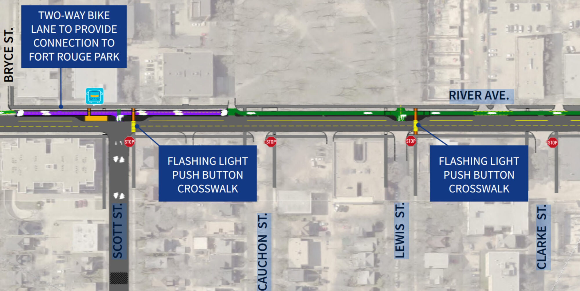
People will ignore the detour to Enfield to/from Braemer to seek a direct route between these destinations, so we should recognize the desire and build to accommodate it. Failure to do so will just lead to people riding the wrong way down the Marion/Goulet bike lanes.
Youville Intersection Improvements
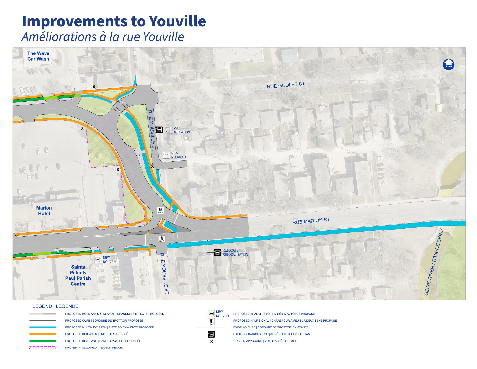
Changes planned for the Youville intersection are very welcome, and definitely improve on the plans from Phase II. They ensure that the city can extend the Egerton-Youville Neighbouhood Greenway north in the future.
Marion Pathway east of Youville
Youville to Archibald
- We would like to see separation of pedestrians and bikes where space permits
- We would like to see R]raised crossings at driveways
- It is good to see the hardened centre line treatment at the intersection of Marion and Archibald. This removes a considerable risk of left hook collisions at the entrance to the Tim Horton’s/
- Domo-Maple Leaf width restrictions (and possible gap)
- Could a crossing of Marion @ Turenne or the CNR Stockyards spur be used to alleviate this?
- There appears to be a vacant industrial parcel running parallel to the rail line that might be used as a pathway north to connect into the Holden Neighbourhood. Assessment 6032188000, ID 183288
- It would avoid crossing the Domo and Maple Leaf parking lots, which would definitely be a benefit.
- Could a crossing of Marion @ Turenne or the CNR Stockyards spur be used to alleviate this?
- Please ensure that the traffic signals at Marion and Dufrense can be activated by someone on a bicycle without having to access the sidewalk.
- Prosper Ave should really be shown as a proposed neighbourhood greenway all the way from Archibald to the Happyland Park pathways, as this will be a travel route for people biking through to Marion and the Dufrense neighbourhood.
- This does not entail any additional changes along Prosper
Marion @ Archibald Intersection
- The proposed design shows a gap between Marion and start of Archibald pathway in the northeast corner of the intersection.
- A multi-use pathway or bike path and sidewalk is planned along Archibald from Marion to Plinquet in the near future.
- If you narrow the southernmost median, can you make space for a pathway extension?
- Good to see the centre line hardening – this should reduce turning speeds.
Removal of the Lagimodiere Pathway
It’s good to see that the intersection at Lagimodiere and Dugald will allow for people on foot or bike to traverse all four corners of the intersection
- This minimizes delay.
The proposed widening of Lagimodiere south of Marion St would preclude development of the presently planned pathway along the west side of Lagimodiere.
- The proposed bike network released as part of the Phase II TMP2050 public engagement process drops the pathway along Lagimodiere in favour of a pathway along Speers Rd which would be extended into the collector street network of the Public Market Lands development, with connections to Marion St at approximately 765 Marion and Marion @ Dupuy Av.
- This plan has not been approved, and has not even undergone full public engagement.
- We do not feel that the pathway along Lagimodiere should be dropped, as doing so creates a significant gap in the bike network.
- It is unlikely that homeowners along Lagimodiere will ever condone widening of Lagimodiere.
- The planned widening of Lagimodiere between Marion and Dugald Rd included in this plan calls for purchase of homes adjacent to the sections of Lagimodiere to be widened. Is that also being suggested for the segments south of Maginot?
- The proposed bike network released as part of the Phase II TMP2050 public engagement process shows an at grade railway crossing of the CNR Sprague line just north of the current terminus of Speers Rd. that would provide a walking and cycling connection to Dawson Rd North, just west of the CNR St. Boniface Stockyard railway spur. In the absence of this rail crossing, the nearest access to Marion St would be the planned Public Market Lands collector street intersection near 765 Marion St.
Detour Distances – Elizabeth Rd to Dugald Rd
| Route | Distance | Detour Factor | Notes |
| via Lagimodiere | 1,670 m | N/A | |
| via Speers-Dawson-Panet-Dugald | 2,550 m | 53% | |
| via Speers-Pulbic Market Lands-Marion-Panet-Dugald | 3,225 m | 93% | |
| via Speers-Stockyards Spur – Holden – Dugald | 2,110 m | 32% | This distance assumes that the crossing of the Spague line would be placed further south, closer to the St. Boniface Stockyards spur. |
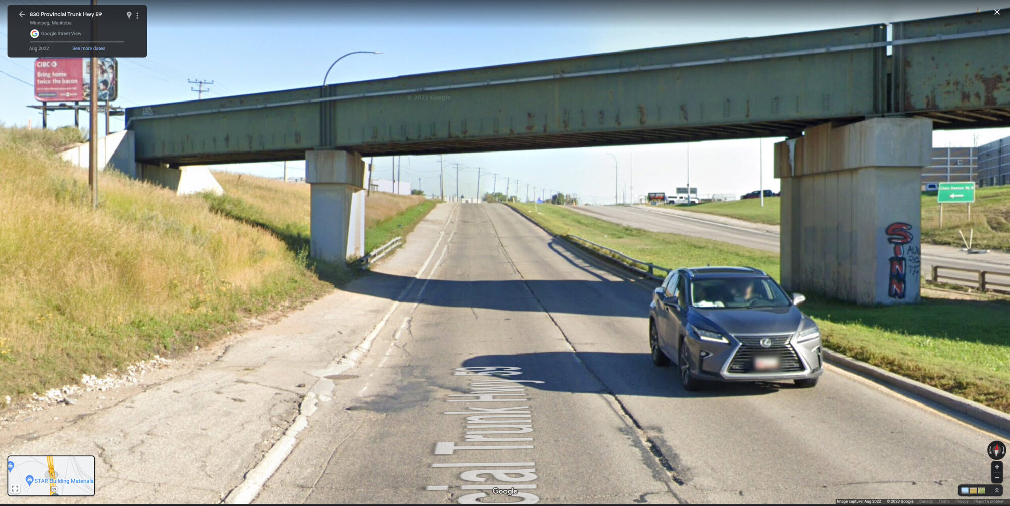
Note that the city has previously constructed pathways under rail crossings next to major arterial roads such as Lagimodiere.
More Reading
You can read up on previous recommendations, including relevant best practices and design guidelines, here.
Final Bike Winnipeg Recommendations
You can view our submitted recommendations below.