Bike Winnipeg has reviewed the Point Douglas Secondary Plan and we’re excited about its vision for an active, transit-oriented, and climate-resilient community. However, to make this vision a reality, we need your voice to ensure the plan includes strong policies for safe cycling and walking infrastructure.
Point Douglas Secondary Plan Recommendations
We are very happy to see that the vision for Point Douglas will support an ”active and public transportation-oriented, climate-resilient, complete community” (pg. 6). This is a commendable and attainable goal for the development of the Point Douglas neighbourhood. The central location of Point Douglas should lend itself well to car-light lifestyles that depend on shorter trips by foot and bike, but only if planning allows for the development of safe walking and cycling routes within the neighbourhood and to/from adjacent communities.
While the plan does reference cycling in a number of its policy recommendations, we’d like to see policies linked to pedestrian-oriented design that consistently include cycling needs along with pedestrian needs (explicit references to cycling are included in some of the policies linked to pedestrian-oriented development, but not in others that would benefit from such explicit inclusion of cycling).
One gap we see in the draft secondary plan is a lack of guidance and policy regarding secure indoor bike parking requirements as part of the objectives and policy recommendations provided for the development of mid-rise and higher-rise mixed use developments. The presence of secure, indoor bicycle parking is a prerequisite to increased use of cycling as a dependable means of transportation. If people do not feel that their bikes are secure, they will not invest in bikes, and will end up relying on vehicle use for trips that could otherwise be easily carried out on bike. If this plan hopes to achieve the active and public transportation-oriented community it envisions, it will need to include policies calling for the inclusion of secure, indoor bike parking in housing so that people will feel that their bikes are safe.
Public Open House and Survey
Community gathering event details
The City is hosting a public open house on Wednesday, June 4 (3–7 PM). Share your feedback, enjoy food and refreshments, and take part in family-friendly activities. Project team members will be available to chat and answer your questions.
Date: Wednesday, June 4, 2025
Time: 3 p.m. to 7 p.m.
Location: Norquay Community Centre, 65 Granville St.(External link)
Format: Come and go (drop-in)
Food and refreshments will be provided. There will be activities for kids.
Can’t attend in person?
You can also share your feedback online. Take the survey(External link) by Wednesday, June 18, 2025.To learn more, you can review the presentation boards (PDF, 44MB) or read the full draft plan (PDF, 3MB).
Rover Avenue improvements
While not part of the Point Douglas Neighbourhood Plan, construction on Rover Avenue is planned for 2026 — and the City is engaging on both projects at the same time. Since the street needs to be rebuilt, this is a great opportunity to make it more comfortable for people walking, biking, and rolling. The City is considering two options and wants your feedback.
Summary of Recommendations
- We are happy to see strong support for completion of North Winnipeg Parkway in this plan.
- Completion of the North Winnipeg Parkway through the Point Douglas neighbourhood needs to be a top priority of the plan and of the City.
- The plan should:
- Explicitly call for the creation of pedestrian and cycling-oriented streets, not just pedestrian and transit-oriented streets, and
- Include requirements for secure bicycle parking in land use and housing objectives and policy, and
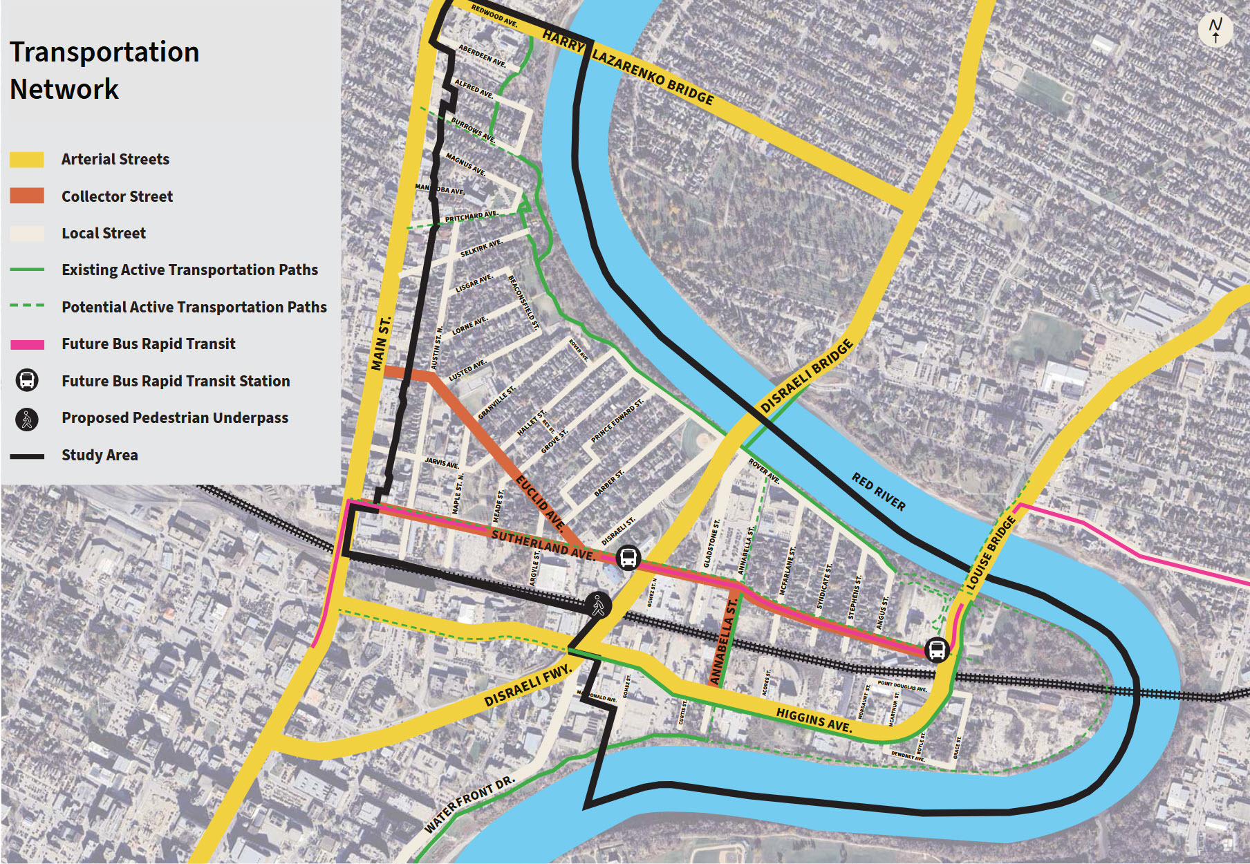
- Ensure that implementation of the Transit Master Plan (specifically, development of a centre-running rapid transit line on Main St and of a rapid transit line on Sutherland Ave) are integrated with the planning and development of walking and cycling networks, and do not diminish from the objective of creating an ”active and public transportation-oriented, climate-resilient, complete community” in Point Douglas.
- Planning of rapid transit and the walking and cycling network should include provisions for safe crossings of Main St in multiple locations, including:
- A crossing located between Selkirk and Redwood Aves that would provide access to planned east/west bikeways north of the CPKC Keewatin rail line (Flora, Manitoba, and/or Burrows Aves),
- A crossing located between the CPKC Keewatin rail line and Dufferin Ave to provide convenient access to R.B. Russell Vocational School, and
- A crossing located south of the CPKC Keewatin rail line to provide access to the Alexander Ave Neighbourhood Greenway.
- Planning of rapid transit and the walking and cycling network should include provisions for safe crossings of Main St in multiple locations, including:
Resources
- Point Douglas Secondary Plan public engagement portal
- Bike Winnipeg Ward Priority Maps
- Draft Pedestrian and Cycling Strategies Update
- Eastern Corridor Study
- Transit Master Plan
Your Voice Matters!
The more people who speak up for walking and cycling, the stronger our case for a people-first Point Douglas. Let’s make sure the plan delivers on its promise of a healthy, sustainable, and connected community.
See you on June 4, or online before June 18!
Highlights from the Draft Secondary Plan
Below are some of the MORE CYCLING SPECIFIC elements of the plan that we thought were worth drawing your attention to. See the resources above for links that will allow you to dig deeper into the plans vision, objectives, and recommended policies.
2 – Planning Vision and Objectives
2.1 Vision
- It is good to see the commitment that “Walking and cycling throughout the neighbourhood will remain convenient in all seasons” (pg. 6).
2.2 Overall Objectives
- We are very happy to see that the vision for Point Douglas will support an “active and public transportation-oriented, climate-resilient, complete community” (pg. 6).
- This is commendable and attainable, but requires supporting policies to create both a network of safe routes as well as provisions for safe, secure, bicycle parking (both short term and long-term).
2.2.2 Grow
- 2.2.2.j “Build complete streets – particularly on Austin Street, Euclid Avenue, and Sutherland Avenue – that support community gathering spaces, economic activities and opportunities, and people walking, cycling, and using transit” (pg. 8).
- 2.2.2.k “Leverage planned rapid transit infrastructure along Sutherland Avenue to facilitate development along the Rapid Transit Line in North Point Douglas and of the South Point Douglas Major Redevelopment Site as a complete community” (pg. 8).
- 2.2.2.l. “Encourage Transit Oriented Development along Sutherland Avenue that includes places for people to live, work and play” (pg. 8).
- 2.2.2.m. “Identify infrastructure improvements necessary to accommodate future development as envisioned in the Plan” (pg. 8).
2.2.3 Nurture
- 2.2.3.a “Plan for people of all ages, with a focus on children and youth and the next seven generations” (pg. 8).
- Comments:
- Designs need to accommodate all ages and abilities, and
- Designs need to meet future volume expectations that will allow us to meet our emissions reduction targets, even with population growth.
3 Land Use
- The plan needs to include provisions for bicycle parking in housing, moving from optional to required as density increases.
- Secure indoor bicycle parking is needed to support the car-light intent of the neighbourhood plan.
- As with section 3.3.7, which calls for the city to consider “incentives to support developers in the integration of sustainable design into their developments” (pg. 11), we would like the plan to recommend that the City consider incentives to support developers in the integration of secure bicycle parking into their developments.
3.1 Land Use Objectives
- An objective stating that development should meet the needs for bike parking (both short term and long term) is needed to ensure that implementation of the plan will encourage cycling trips.
- This objective would be in line with the desire to promote sustainable transportation, and is in line with the goal of producing affordable housing, as access to cycling reduces overall transportation costs, which are tightly linked to housing and affordability.
- Secure bike parking should be considered as a prerequisite to the goal of developing an “active and public transportation-oriented, climate-resilient, complete community” (pg. 6).
- An objective should be added to ensure that provisions are made for the accommodation of car shares.
- This will aid in the reduction of car ownership, which will in turn lead to reduced vehicle trips.
- Existing and planned cycling facilities are also an asset that we should be leveraging.
3.5 Mid-Rise Mixed-Use Area Policies
- We would like to see bicycle parking requirements included in this section. Sections 3.5.22 and 3.5.23 support this as they reduce parking requirements; secure indoor bicycle parking is needed to support the car-light intent of the neighbourhood plan.
- “The public realm will be designed to support social activity and alternative forms of transportation, with strong connections to the rapid transit network along Sutherland Avenue” (pg. 13).
- 3.5.22 “No more than 0.5 off-street parking spaces per dwelling unit shall be required” (pg. 14).
- 3.5.23 “Notwithstanding policy 3.5.22, there shall be no minimum parking requirements for development on lots abutting Sutherland Avenue” (pg. 14).
- 3.5.26 “Innovative and flexible solutions for parking management are encouraged, including but not limited to the following:
- 1. Shared parking agreements;
- 2. Dedicated spaces for car-share vehicles; and
- 3. Provision of lockable bicycle parking spaces”( pg. 15).
- We need to call for inclusion of secure indoor bicycle parking, not just lockable bicycle parking spaces.
3.6 Higher-Rise Mixed Use Area Policies
- 3.6.13 “Consideration should be given to the creation of additional public streets in the redevelopment of large blocks to increase walkability and enhance the pedestrian-oriented public realm” (pg. 17).
- Consideration for pathways with mid-block crossings should also be considered?
- Crossings of Higgins (which will remain as a truck route) may limit opportunities, as there may be a limit on the number of crossings permitted.
- It may be better to define cycling routes north and south of Higgins, especially if crossings are limited.
- Sub Area C would benefit from a cycling route located between the rail line and Higgins providing an alternative to travel on Higgins Ave, which will remain as a truck route.
- This may also fit in with the rail policies as structures may not be allowed too close to the tracks.
- Any such route would need good access to Annabella.
- Consideration for pathways with mid-block crossings should also be considered?
- 3.6.14 “There shall be no minimum parking requirements in the Higher-Rise Mixed-Use Area. Loading facilities for both person and service loading and delivery loading shall be required and provided where necessary” (pg. 17).
- 3.6.15 “Innovative and flexible solutions for parking management, including shared parking agreements and providing dedicated spaces for car share vehicles, are encouraged” (pg. 17).
- Secure indoor bicycle parking should be required.
Sub Area A (Higgins Avenue and Riverfront)
- 3.6.21 “Consideration should be given to the creation of additional public streets in the redevelopment of large blocks to increase walkability. Examples include:
- 1. Potential extension of Macdonald Street and/or the creation of a new north-south street through the existing industrial site to the east of Macdonald Street; and
- 2. Additional public streets to facilitate development on the former industrial lands east of Higgins Avenue” (pg. 17).
- Make use of parks to create natural diverters with provisions for through traffic of people on foot or bike.
4 Public Realm
- “Objectives and policies guide the provision of new parks and improvements to existing parks, coordinated with enhancements to other elements of the public realm, to create a connected and cohesive public realm network serving Point Douglas. This includes connecting the North Winnipeg Parkway, an active transportation corridor intended to connect The Forks to the Chief Peguis Trail along the Red River, through Point Douglas” (pg. 20).
4.1 Public Realm Objectives
- 4.1.g “Establish and/or improve off-street connections between parks containing a variety of unique facilities” (pg. 21).
- 4.1.j “Extend the linear parkway system along the Red River throughout the Plan Area” (pg. 21).
4.2 General Public Realm Policies
- 4.2.4 “Safe and accessible transportation connections to adjacent neighbourhoods, parks and recreational opportunities will be established and/or enhanced” (pg. 22).
- Where are the desired connections across Main St?
- Add that east/west connections leading to Main St must allow for signalized crossings of Main St.
- Must allow for the development of an all ages and abilities connection to Charles St, including a signalized crossing of Main St.
- A mid-block crossing of Main St could be facilitated with a pedestrian corridor, but only if not located at a local street intersection.
- North of Portage, Main St will make use of centre-running transit lanes (pg. 59-60 Transit Master Plan).
- Crossings will need to align to allowed crossings of those Main St centre-running transit lanes.
- Must allow for the development of an all ages and abilities connection to Charles St, including a signalized crossing of Main St.
- Note inadequacy of recently installed Selkirk – Flora connection (west side of Main St).
- Unstructured crossing of travel lanes on Selkirk and Flora.
- Generates conflict with pedestrian traffic.
- How is this building for 7 generations into the future?
- 4.2.7 “Opportunities (including existing rights of way, surface parking lots, derelict properties, environmental remediation, and land acquisition) to develop new parks and off-street connections will be encouraged.” (pg. 22).
4.3 Street Design Policies
- This may be the section to add an objective of including continuous sidewalks and pathways at local street intersections.
4.4 River Connection Policies
- 4.4.1 “The retention, acquisition and improvement of riverbank lands shall be prioritized to:
- 1. Restore riparian habitat;
- 2. Increase public access to waterways; and
- 3. Connect the North Winnipeg Parkway multi-use trail from Annabella Street south of Higgins Avenue to Michaëlle Jean Park by establishing a continuous linear parkway system along the Red River throughout the Plan Area” (pg. 24).
- 4.4.2 “Establishing a continuous linear parkway system along the Red River throughout the Plan Area is a priority of this Plan. The City shall assemble and enhance riverbank properties, or portions of properties, when suitable sites become available, whether through acquisitions or as part of the development application process” (pg. 24).
- 4.4.4 “Enhancements along the Rover Avenue right-of-way should be considered, including:
- 1. Development and maintenance of small park areas and other amenities of interest;
- 2. Provision and enhancement of the active transportation environment; and
- 3. Adjustments to vehicular traffic movement and speed as appropriate” (pg. 24).
- The plan should add in a statement to the effect that improvement of the intersection of the Disraeli AT Bridge pathway and Rover will be included in the enhancements along the Rover Avenue right-of-way to provide a safer intersection; better visibility, priority to walking and cycling movements.
5 Mobility
- “The planned routing of bus rapid transit along Sutherland Avenue provides a significant opportunity to re-imagine mobility in the Plan Area. The proposed bus rapid transit design includes a transit boulevard and pedestrian and cycling infrastructure on Sutherland Avenue, a new signalized intersection at Main Street and Sutherland Avenue, a new pedestrian underpass of the CPKC railway tracks near the Disraeli Freeway, and two rapid transit stations along Sutherland Avenue” (pg. 26).
- Push back against a two-way AT sidepath on a two-way street.
5.1 Mobility Objectives
- The Mobility policy objectives are as follows:
- a. “Provide an efficient and accessible transportation network that considers all users and modes of transportation, prioritizing infrastructure that focuses on the accessibility, comfort, and safety of cyclists, pedestrians, and transit users.
- b. Leverage private sector development and public infrastructure investments to make active and public transit attractive, efficient and easy to use with the aim of moving 50 percent of people by sustainable modes by 2050, as outlined in the City of Winnipeg Transportation Master Plan, Transportation 2050.
- c. Improve personal mobility, promote healthy living, and reduce greenhouse gas emissions.
- d. Ensure that the active transportation network is planned, designed, implemented and maintained to address year-round pedestrian needs.
- e. Incorporate complete streets wherever possible and promote innovative design, such as shared streets, where appropriate;
- f. Protect Higgins Avenue as a primary truck route” (pg. 26).
- Recommendations –
- d – add cyclist needs.
- If the need to have the painted bike lanes on Annabella Ave upgraded to a separated cycling facility could be highlighted here or somewhere else in the plan, it would be helpful.
- Provide cycling alternatives to Higgins Ave if no cycling facilities are included on that roadway.
5.2 General Mobility Policies
- 5.2.1 “Proposed changes to cycling and pedestrian networks in the Plan Area should align with the vision and direction strategies of the City of Winnipeg Pedestrian and Cycling Strategies and should accommodate both recreational and commuter travel” (pg. 26).
- Comments
- The provision of safe, connected, and intuitive pedestrian and cycling connections across Main St. needs to be incorporated into plans for the development of rapid transit routes along Main St and Sutherland Ave.
- Connections across Main St. need to connect with existing or planned east-west bikeways along:
- Sutherland and/or Jarvis Ave,
- Alexander Neighbourhood Greenway, and
- Flora/Manitoba and/or Burrows Ave bikeway.
- We need to avoid connections that increase the likely conflict between people on foot and bicycle, such as the connection on the east side of Main St between Flora Ave and Selkirk Ave.
- Comments
- 5.2.2 “Improvements to the active transportation network should prioritize the following:
- 1. Streetscaping improvements within the pedestrian realm in conjunction with the design and implementation of the Bus Rapid Transit Network along Sutherland Avenue, to support new developments and businesses, and create a positive pedestrian environment. This shall include introduction of a sidewalk on the south side of Sutherland Avenue;
- 2. Providing links between unconnected portions of off-street pathway systems, sidewalks, and cycling routes;
- 3. Providing wider sidewalks in existing and emerging activity areas to accommodate pedestrian traffic and amenities, particularly where outdoor seating and retail activities are to occur” (pg. 26-27).
- Comments:
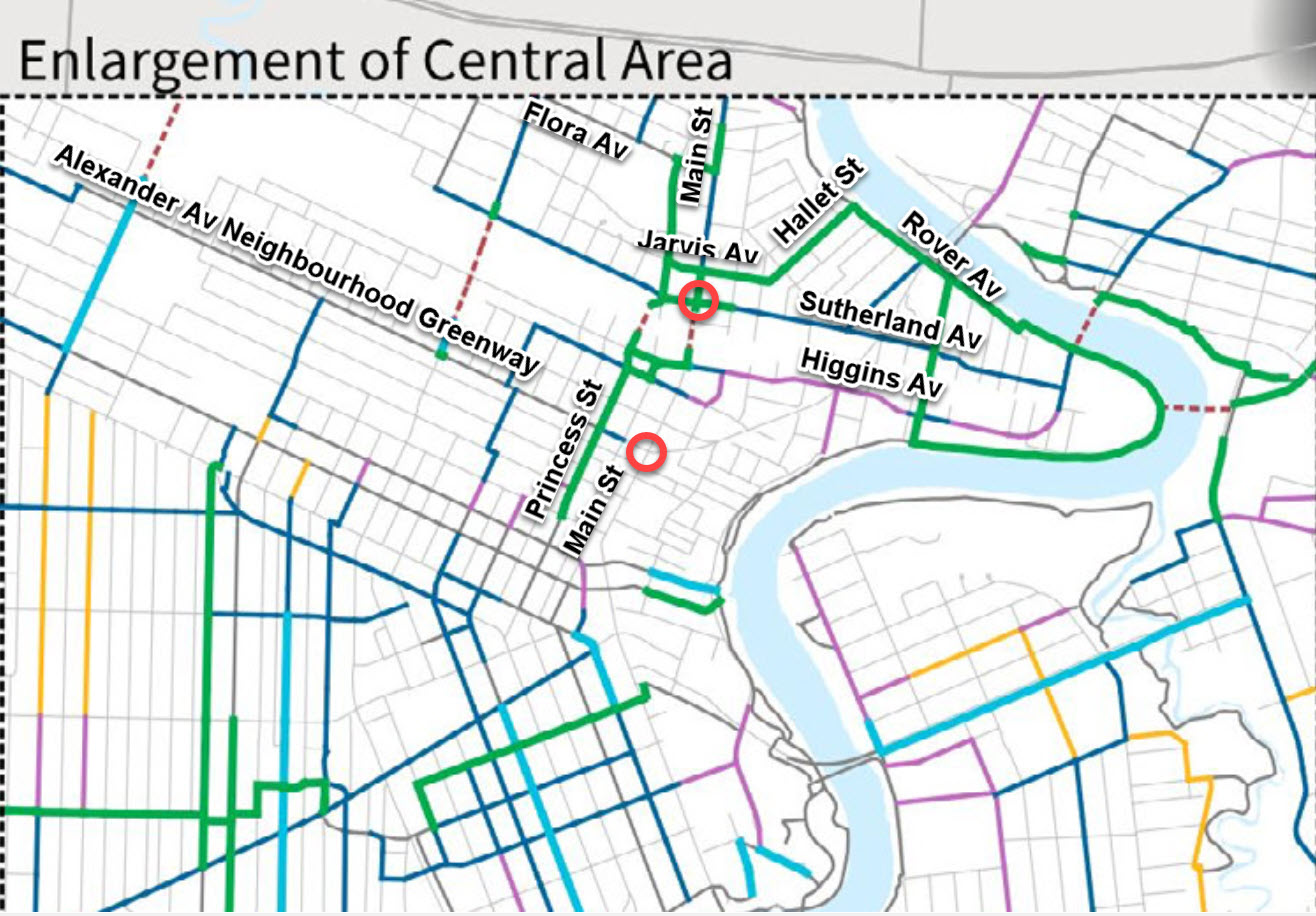
- Item 2 matches a key priority of Bike Winnipeg; filling the gap in the North Winnipeg Parkway between Magnus Ave and St. John’s Park.
- Completing the gap between Aberdeen Ave and St. John’s Park should be the top priority. Additionally, the gap between Magnus Ave and Burrows Ave needs to be filled, and improvements are needed in the following segments:
- The North Winnipeg Parkway needs to be given priority over the back lane between Alfred and Burrows, and the baffles that currently restrict movements by larger bikes and bike trailers need to be removed.
- The section through Aberdeen Park should be fixed up. Could Aberdeen be terminated further east to provide more space for the pathway to be better routed around the park?
- Completing the gap between Aberdeen Ave and St. John’s Park should be the top priority. Additionally, the gap between Magnus Ave and Burrows Ave needs to be filled, and improvements are needed in the following segments:
- Item 2 matches a key priority of Bike Winnipeg; filling the gap in the North Winnipeg Parkway between Magnus Ave and St. John’s Park.
- 5.2.4 “Consider development of shared streets, including Rover Avenue, that prioritize pedestrian movement and safety and that minimize segregation between different modes of transportation. Shared streets are to be compatible with the Provincial Shared Street Regulation” (pg. 27).
- 5.2.6 “Consideration may be given to constructing an active transportation bridge connecting South Point Douglas to Whittier Park to enhance the local economy, improve accessibility and stimulate greater value and use of critical public recreational and cultural assets” (pg. 27).
- 5.2.7 “Streetscaping improvements are encouraged, particularly along Sutherland Avenue, Higgins Avenue, and Euclid Avenue, including:
- 1. Increasing the number of street trees and other pedestrian amenities including street furniture, pedestrian-level lighting, green infrastructure, and placemaking;
- 2. Integration of cycling and active transportation facilities such as bike racks and lockers;
- 3. Maintenance and/or construction of wide sidewalks that that meet accessibility standards;
- 4. Improvements to pedestrian crossings” (pg. 27).
- Comments:
- The following should be added:
- Protected bike lanes should be part of the planning for redevelopment of Sutherland Ave.
- Cycling facilities on Sutherland Ave would provide a needed connection across Main St to R.B. Russell Vocational School.
- Sutherland would also act as a connection to the proposed King/Princess St crossing of the CPKC Keewatin rail line (Map 6, pg. 70 of the Draft Pedestrian and Cycling Strategies Update).
- Snow storage space to help manage snow clearing operations to ensure that walking and cycling infrastructure can be efficiently maintained through winter.
- Continuous sidewalks and pathways to improve yielding behaviour of vehicle drivers turning onto local streets.
- Protected bike lanes should be part of the planning for redevelopment of Sutherland Ave.
- The following should be added:
- 5.2.9 “Decisions regarding development and infrastructure should consider the Winnipeg Transit Master Plan including the primary transit network (launching in 2025), the short-term and long-term network plans” (pg. 27).
- Comments:
- The draft Pedestrian and Cycling Strategies Update includes a highest priority cycling route along Jarvis and Hallet that would provide a good connection across Main St to services and amenities, both current and/or planned, that need to be considered in planning for the development of rapid transit along Main St and Sutherland Ave.
- Plans to develop a centre-running transitway on Main St in the near future could remove any crossing of Main St. at Jarvis Ave, effectively eliminating this route.
- The Jarvis – Hallet bike route is included in the draft PCS Update, has highest priority, and would provide an excellent connection between the North Winnipeg Parkway and the southern end of the infill development area and destinations to the east of Main St, including a planned grade separation of the CPKC Keewatin rail line on the King/Princess St alignment.
- Provisions for a safe crossing of Main St located between Selkirk Ave and Redwood Ave should be included in planning for the implementation of rapid transit along Main S. to provide a connection to a planned east/west cycling route.
- The draft Pedestrian and Cycling Strategies Update includes a highest priority cycling route along Jarvis and Hallet that would provide a good connection across Main St to services and amenities, both current and/or planned, that need to be considered in planning for the development of rapid transit along Main St and Sutherland Ave.
- Comments:
- 5.2.14 “Road safety improvements shall be informed by the Winnipeg Road Safety Strategic Action Plan, with a particular focus on improving pedestrian and cyclist safety and reducing collisions on arterial streets within the Plan Area” (pg. 28).
Recommendations:
- Further policies we think would align with the vision and objectives of the plan include:
- Collector streets should be constructed with protected bike lanes to provide all ages and abilities cycling infrastructure.
- Local streets should be designed for low traffic and speeds of 30 km/hr.
- Greenspace should be incorporated into neighbourhood traffic calming.
- Where used to eliminate cut through traffic, such greenspace should include pedestrian/bike paths to ensure people on foot or bike are not forced to detour.
- Intersections should be designed to meet the needs of all ages and abilities.
- Protected intersections where collector or arterial streets meet.
- Raised crossings where local streets meet collector or arterial streets.
- Minimal crossing distances.
- Median where mid-block crossings are utilized.
5.3 Vehicular Parking, Access, and Curbside Management Policies
- 5.3.1 “Innovative approaches to vehicle parking and access are encouraged. This may include the introduction of dedicated parking spaces for car share vehicles and public electric vehicle charging stations.”
- Comments:
- Add bicycle parking, both short term and long term.
- Comments:
5.4 Railway Policies
6 Building Community
6.4 Community Facilities Policies
- 6.4.2 “New community service facilities, to support population growth and complete communities, are encouraged to be:
- 1. Supported by a well-designed public realm and located in highly visible and accessible locations with strong pedestrian, cycling, and transit connections;” (pg. 31).
- 6.4.4 ”Community service facilities are encouraged to include:” (pg. 31).
- Add bicycle parking?
6.5 Safety Policies
7 Housing
7.1 Housing Objectives
- d “Encourage housing development that ties in with the existing neighbourhood character and plans for a pedestrian and transit-friendly community, including higher residential densities near services and along the rapid transit corridor” (pg. 33).
- Encourage development that encourages trips by bike,
Direct access to cycling routes, and
- Secure, indoor bicycle parking.
7.2 Housing Policies
- Add a policy to develop requirements for secure, indoor bicycle parking.