The city is calling for feedback on their proposals for bike routes in St Boniface. Today is the last day to respond to their survey at https://engage.winnipeg.ca/stboniface-walk-bike .
Here is what Mark submitted on behalf of Bike Winnipeg:
We would have much preferred that the city take a network approach to the study rather than the simplistic choice of asking participants and stakeholders to select one route over another. If the city is at all sincere in its desire to shift people out of their cars and into sustainable modes of transportation like biking, then they should be looking to maximize connectivity in our neighbourhoods. Focusing on a single route and using the budget as an excuse for that choice is a roadmap to failure. We need to work toward a city where all destinations are easily accessible by foot, by bike, and by bus (or by a combination of these options), and we need to find the budgets to make it happen.
People will choose sustainable options like walking or biking when direct, convenient, and safe routes are provided from their homes to their destinations. When local destinations are easily accessible by foot or by bike, people tend to make use of their local amenities. For modes of transport like walking and cycling, distance makes a difference. Unnecessary detours discourage walking and cycling and drive people to their automobiles, where they tend to undertake longer trips, increasing emissions, and increasing congestion.
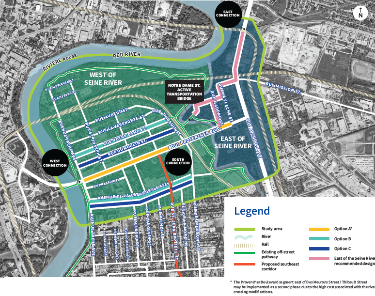
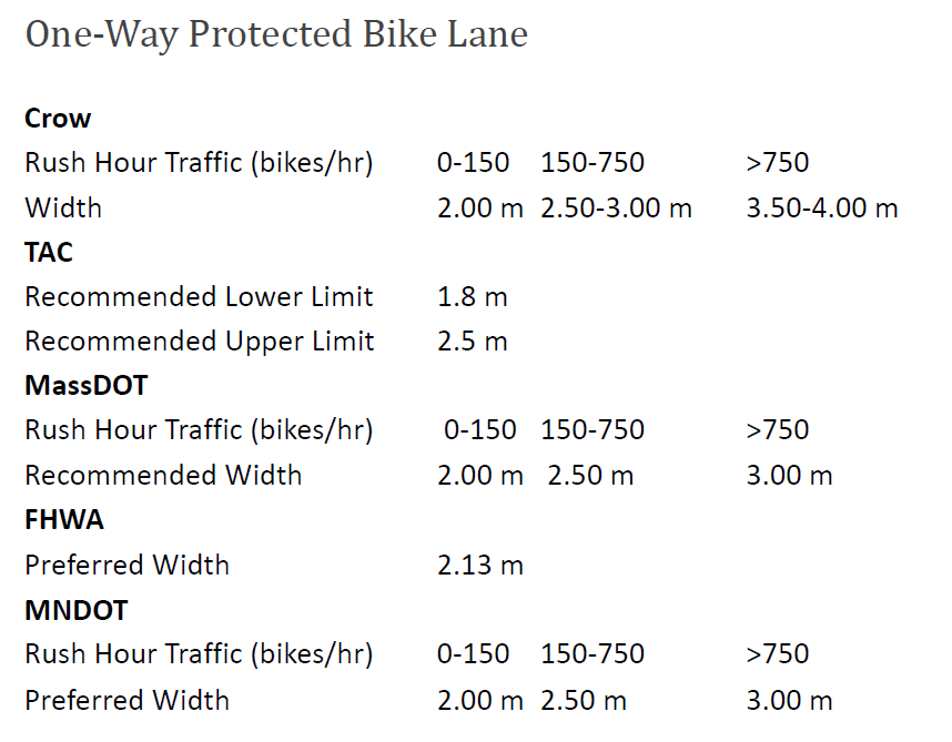
Protected bike lanes along Provencher Avenue would provide the kind of direct access, comfort, and safety that enable 15 minute neighbourhoods. Options at the 2.2m width would provide connectivity to people in the immediate area of the shops along Provencher while also providing direct access to the downtown, the north, the south, and the northeast. None of the other options presented come close to providing that universal connectivity. For these reasons, we recommend that the option to provide protected bike lanes along Provencher be selected, with widths enabling people on bikes to pass each other.
The option for de la Cathedrale, which stops at St. Jean Baptiste, does not even manage to provide connectivity to anyone east of Des Meurons, including critical connections along Egerton/Youville that are currently being built up south of the site through the enhanced summer bike routes program, through the recent Fermor Avenue Seine River Bridge rehabilitation, and through planned improvements via the Moving on Marion project and recent motions to extend the Youville/Egerton route south to the Bishop Grandin Greenway and beyond. Where a barrier such as a busy street like Des Meurons exists, it is important that our cycling network provide routes on both sides of the barrier, not just one side of the barrier.
A second issue with the design provided for de la Cathedrale is that the number of driveways and entrances that the pathway would need to cross are excessive, which creates a potential safety hazard.
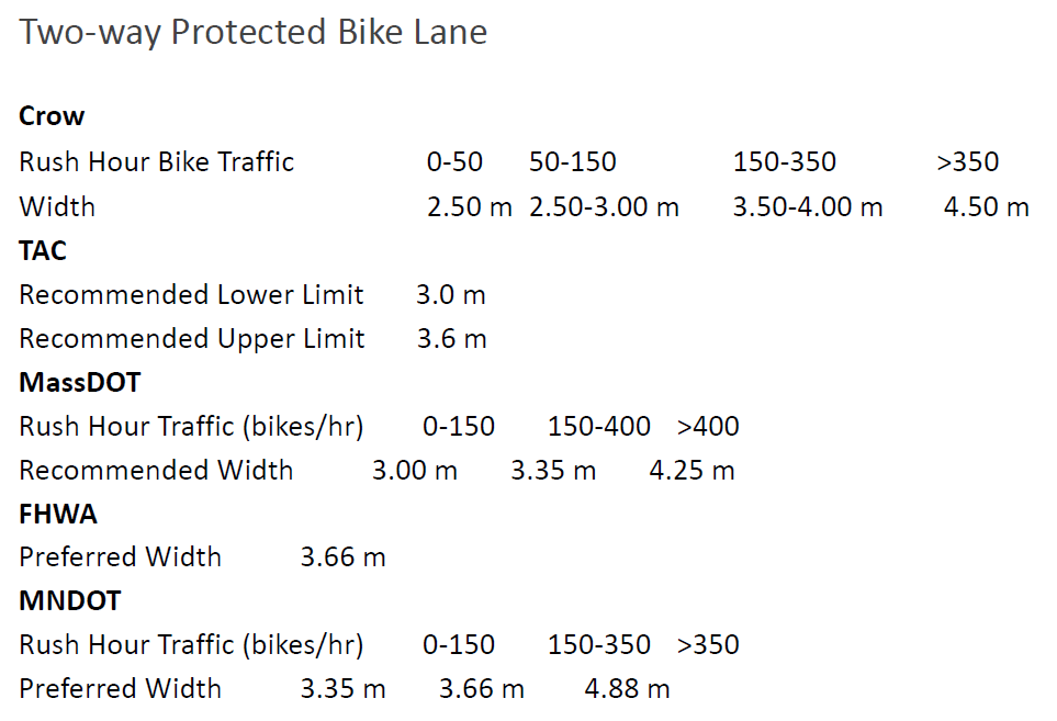
A third critique is that the bike path widths provided are below minimum standard widths for all but the least busy bikeways. A better solution would be reduced speeds on de la Cathedrale along with traffic diversion to reduce traffic volumes (for example at Aulneau). That creates a fairly affordable option, and we would like to see it added along with the protected bike lanes along Provencher.
The Notre Dame route is a cheap option that should be considered as an addition and supplement to the Provencher option, but not as a substitute for it.
The cost of these projects pales in comparison to the budget we put into our roadway network. If choices on budget need to be made, we should be choosing the sustainable options, not the status quo that simply continues us down the path to climate catastrophe and fiscal insolvency that we are currently racing down.
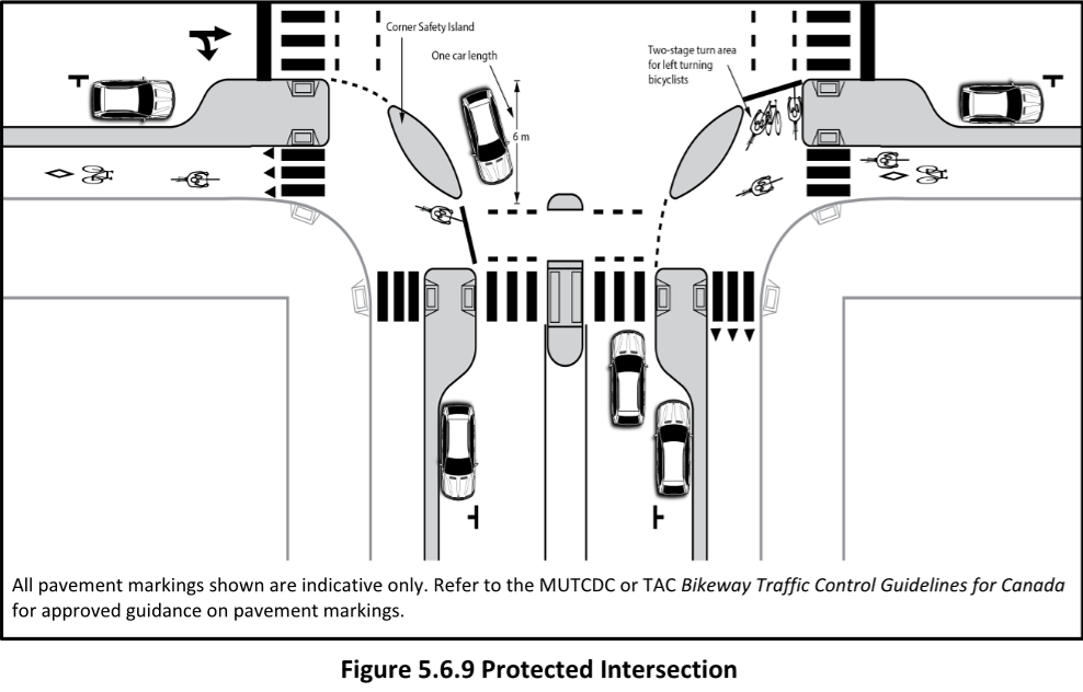
Protected Intersections
TAC
Setback Distance: 6m (one car length)
Source: TAC Geometric Design Guide for Canadian Roads (2017)
CROW
Setback Distance: 5m
Source: CROW Design Manual for Bicycle Traffic
NACTO
Setback Distance: 4.25m → 6.1m
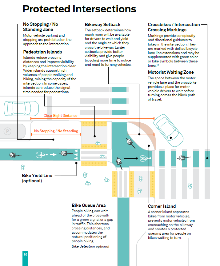
Source: NACTO Don’t Give Up at the Intersection