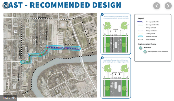
The City has published a “recommended design” for the Wolseley to Downtown Walk/Bike Project, and is seeking public input through an online survey (open until Feb. 9) and an open house January 29th 6 p.m. – 8 p.m. at the Westminster United Church (745 Westminster Ave).
This is an important project for cyclists and pedestrians, please be sure to look at the plans and express your opinion.
The City will be particularly interested in hearing from people who live near the area. Many businesses and residents with other priorities have been expressing their interests.
Some of the benefits we anticipate that a safer, more comfortable, better connected bike network in Wolseley and West Broadway would bring:
- Increased safety and comfort for the thousands of people who walk or bike in and through Wolseley and West Broadway each and every day.
- Increased mobility options for those who have expressed a desire to walk or bike, but have felt unable to get out of their cars and onto their bikes because they do not feel safe sharing space on roadways that fail to accommodate them.
- By providing the means for increased use of active transportation, the plan provides a means for residents and commuters to decrease transportation costs and thus increase their disposable incomes, a likely benefit for area restaurants, services, and retailers.
- A healthier, greener community.
Bike Winnipeg supports the City’s direction on this project, but we see room for improvement. Please review the comments we have put together below and talk to the City about any of these ideas that make sense to you. Feel free to tell us about any other changes you recommend.
Recommended Changes to Latest Wolseley to Downtown Designs
- Improve the intersection @ Granite Way and Osborne
- Add a raised crossing from the bike lane to the separator island where you wait to cross Osborne (similar to what was done at Fermor at St. Annes Rd).
- Reprogram the crossing light to reduce wait times for people crossing Osborne by bike or foot.
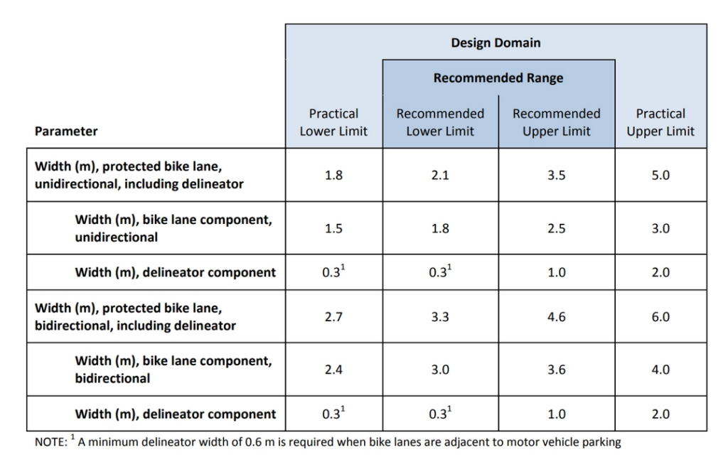
- Widen the protected bike lanes recommended along Granite Way to reflect the number of people expected to bike along this route. 2.8m wide is sub-standard for a main link in the city’s bike network.
- If space restrictions make it impossible to widen this pathway, designers will need to revisit the decision to allow unrestricted two-way traffic between Osborne and Balmoral and reduce through-traffic on Granite Way.
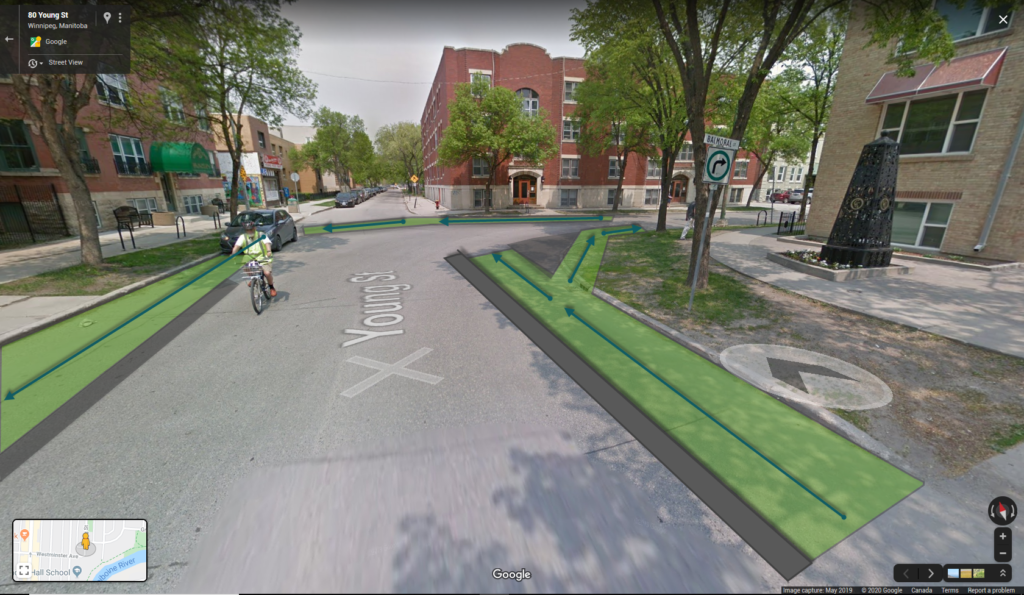
- At Young at Balmoral, provide a place for cyclists to stop and wait for a safe gap in traffic before crossing Balmoral and continuing north into the Broadway Neighbourhood Centre and Park.
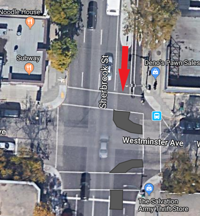
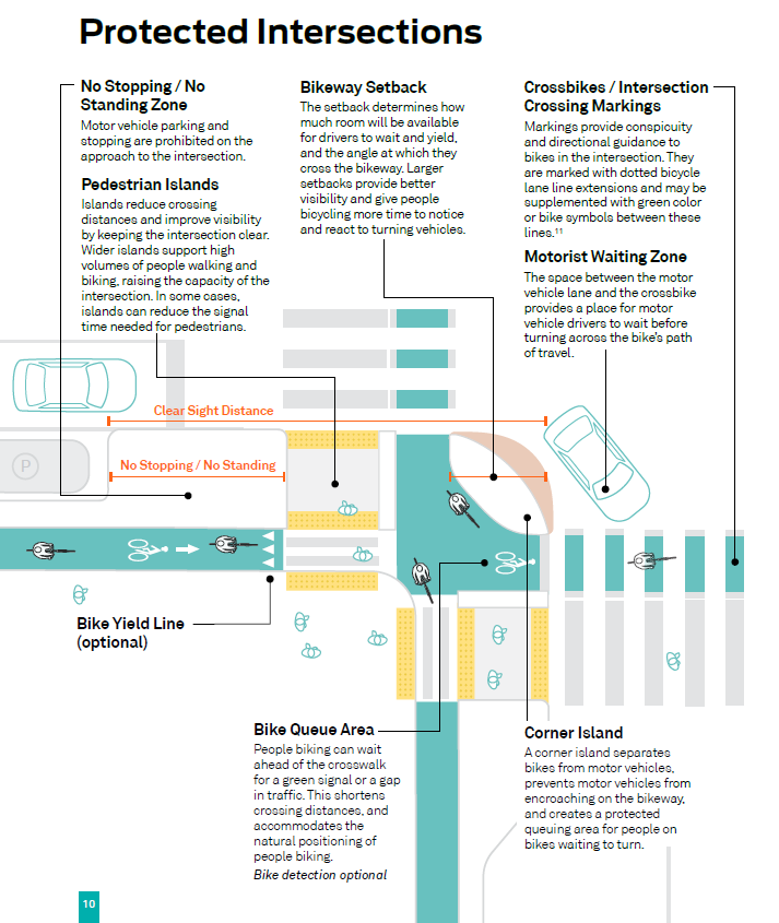
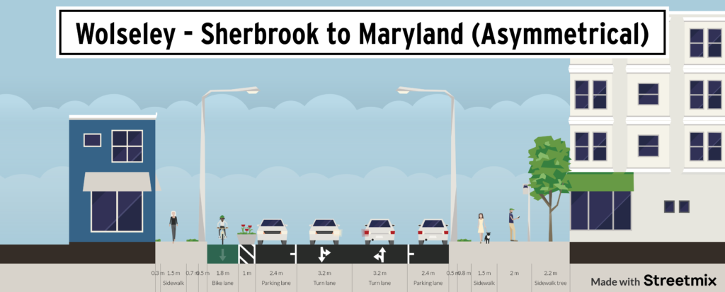
- Improve the Westminster intersections at Sherbrook and Maryland by extending the bike lane concrete curb protection back to the intersections and to provide fully protected intersections. The current setups calling for a two-stage turn leave waiting cyclists too exposed to traffic for comfort.
- Convert the turning lanes on Sherbrook to parking that willl also provide a buffer for a protected bike lane; given the restricted vehicle access proposed, the need for a turning lane seems negligible.
- Widen the 1.8m cycle tracks through the central areas of the study zone to 2.1m (or more) plus buffer to match the width of the protected bike lanes along the eastern sections of Westminster/Balmoral.
- 1.8m is too narrow for the expected level of bicycle traffic along this route. Cyclists need to be able to pass each other.
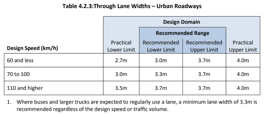
- Narrow the traffic lanes to 3m to accommodate widening of the protected bike lanes.
- Design the intersection at Maryland and Westminster to provide a safe transition for someone biking south along Maryland and turning east onto Westminster.
- For cyclists traveling north over the Maryland Bridges and turning west, add a protected lane westbound on Wolseley between Sherbrook and Maryland.
- For someone riding between Wellington Cr @ Academy and Wolseley @ Greenwood, the detour being recommended from Wolseley to Westminster is a 23% increase in distance, plus additional traffic signals and stop signs. That’s a detour most people will not be willing to make.
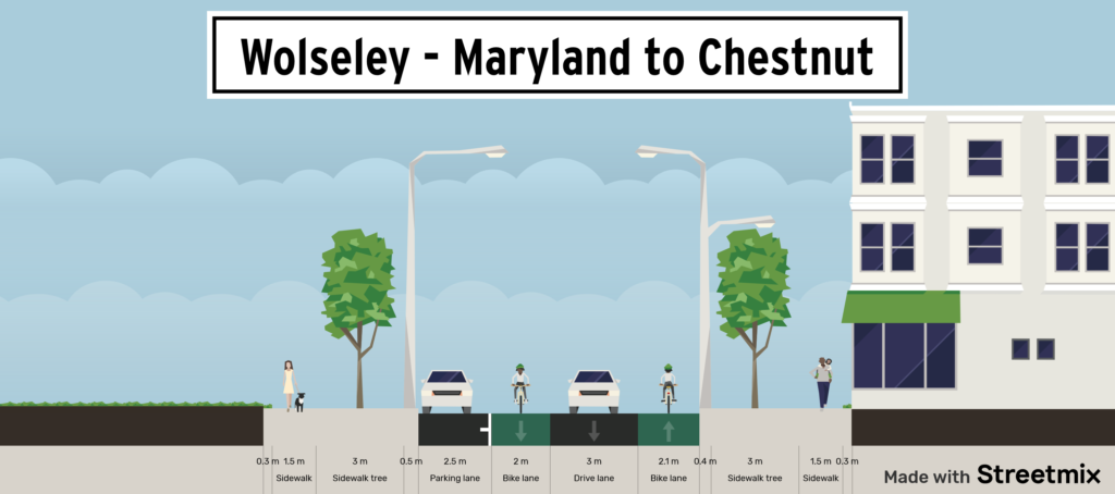
- On Wolseley between Maryland and Chestnut, if there is no room for a protected bike lane running west, add a wide painted buffered bike lane to provide better definition for people on bikes. That would retain the parking, retain the eastbound counter-flow bike lane, retain the westbound traffic lane but would add a bike lane for people biking west instead of forcing them into a mixed traffic lane that is wider than recommended for a mixed traffic lane.
- On Westminster, between Chestnut and Canora, if there is no room for a protected bike lane running west, add a wide painted buffered bike lane to provide better definition for people on bikes. That would retain the parking, retain the eastbound counter-flow bike lane, retain the westbound traffic lane but would add a bike lane for people biking west instead of forcing them into a mixed traffic lane that is wider than recommended for a mixed traffic lane.
- Narrow the turning radii at side street intersections on Wolseley, particularly streets like Clifton that meet Wolseley at an angle.
- Add a half signal at the intersection of Portage with Clifton to provide safe access across Portage Avenue to the Valour Community Centre, other destinations north of Portage, and a less flood-prone route to Polo Park.
This is a critical region for people cycling in the city, as it has the potential to provide safe, convenient connections north/south across the Assiniboine River and east/west from Omand’s Creek and the Polo Park area through to the Downtown. Within the city’s proposed bicycle network, the routes along Wolesley and Westminster/Young/Balmoral/Granite Way are the only east/west connection north of the Assinboine River that connects these areas.
There are no plans to provide safe cycling spaces on Broadway or Portage, and no timeline to upgrade the one sad east/west connection on St. Matthews that consists of substandard painted bike lanes inexplicably alternating with utterly useless sharrows that force people on bike to share the lane with everything else on the road. Failure to improve conditions for people walking or cycling along these few routes means a failure to provide any safe way to travel within or through a central part of the city by any means other than car.
Removing these routes from the planned bike network (or providing substandard facilities that remove them for all but the most confident cyclists) effectively kills any chance at attaining a bike network that accommodates people of all ages and abilities in the city.
We encourage the city and stakeholders to work together to minimize any loss of parking and loading. Parking/Loading bays similar to those installed along Harrow St and Sherbrook St. could be added along areas of Westminster/Balmoral in areas of high demand. We would want to work with designers to ensure that any such design supported safe interaction between vehicles and people on bike or loading on/out of vehicles, and that the planned design supported year round usage.
Similarly, we are open to modifications that keep two way traffic flow in place as long as two one-way protected bike lanes at least 2.1m of usable bike lane in each direction (plus buffer between the bike lane and the travel lane). This would require removal of trees to accommodate a widening of the roadway and would significantly increase the cost of the project. The community would clearly need to show their willingness to remove trees and boulevard space to make this happen. Increased costs would need to be found in the city’s Road Renewals budget without affecting future budgets for walking and cycling improvements.
The safety and well-being of the thousands of people who will benefit from a safer, more comfortable, better connected cycling network need to be at the center of plans for the Wolesley and Westminster/Young/Balmoral/Granite Way corridors.
PDF versions of Bike Winnipeg’s comments: on Recommended Design:
For more information:
City of Winnipeg Web Portal – Wolseley to Downtown Walk/Bike Project
Bike Winnipeg’s June 2019 Submission on the Wolesley to Downtown Preliminary Design