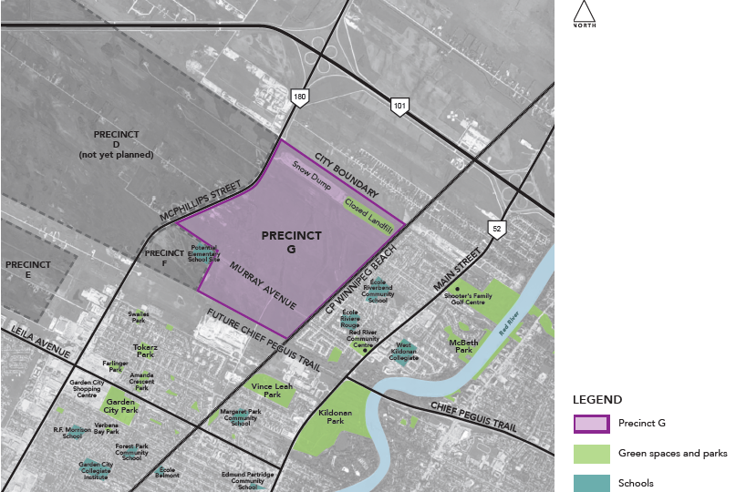
Plans for the development of Precinct G along the city’s northern boundary are moving toward public hearings. On Tuesday, September 4th, the draft Master Plan for Precinct G came before the Standing Policy Committee on Property & Development, Heritage and Downtown Development. This begins a process that will see the plan move towards public hearings and possible council approval, allowing development to begin.
The draft Master Plan for Precinct G has begun the process toward public hearings.
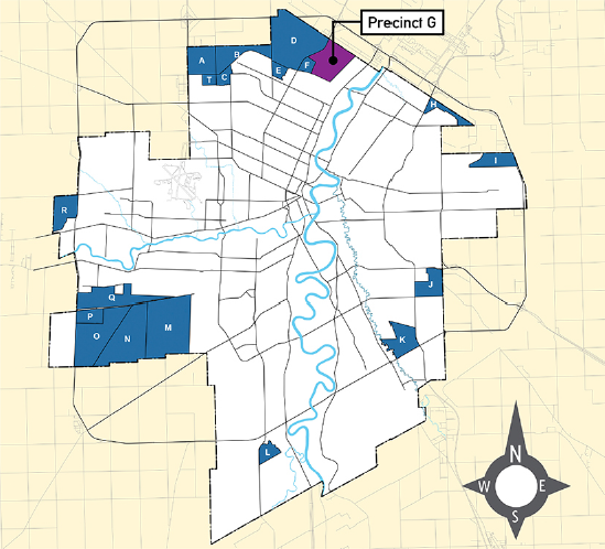
What is the Precinct G Master Plan
Under the city’s Complete Communities planning document, large, undeveloped and un-serviced land areas along the edges of the city are grouped into precincts. Prior to development of a new community precinct, a Precinct Plan must be developed and adopted by city council. The precinct plan aims to ensure that new development is in line with the vision and direction of Complete Communities, and that development will proceed in an organized, logical manner, and in a way that will make use of existing city infrastructure while providing a plan for the development of any new infrastructure required by the new community.
Precinct plans include general plans for among other things, transportation (main roads, public transit, walking an cycling), parks, residential, commercial, and industrial zoning, and water and sewage which are backed up by policy statements that guide more detailed development.
At Tuesday’s meeting, Bike Winnipeg put forward a number of recommended additions and alterations to the plan that we believe would provide a better alignment of the Precinct G plan policies with the city’s Pedestrian and Cycling Strategies. It is our hope that these changes will help promote the creation of a dense, comfortable, well-connected cycling network in the precinct G encouraging more trips into, within, and from Precinct G to be made by bicycle.
Bike Winnipeg Recommendations – Precinct G Draft Master Plan
Vision
Current Wording
An integrated network of pathways, parks, open spaces, and on-street infrastructure will provided pedestrian and bicycle access to amenities located throughout, and adjacent to, the community.
Suggested Wording
An integrated, dense, well connected network of pathways, parks, open spaces, and on-street infrastructure will provide pedestrian and bicycle access for users of all ages and abilities to amenities located throughout, and adjacent to, the community.
Rationale
The “all ages and abilities” language lines up with the vision statement of the city’s Pedestrian and Cycling Strategies, and will provide guidance on bicycle facility selection along collector streets and arterial streets.
The “dense, well connected network” language lines up with direction 1.B.i of the Pedestrian and Cycling Strategies, which calls for the city to “Develop a complete, connected, and dense bicycle network throughout the city” (pg. 291, Pedestrian and Cycling Strategies).
The vision of the city’s Pedestrian and Cycling Strategies consists of a series of inspirational statements that act as the framework to guide the direction of walking and cycling in Winnipeg into the future. The vision statement for the Strategies describes the future “end state”, or result, of implementing the Strategies. The first statement in the Pedestrian and Cycling Strategies vision statement calls for a city where “Walking and cycling are safe, convenient, practical, and attractive transportation choices for people of all ages and abilities “(pg. 99-100, Pedestrian and Cycling Strategies).
Objectives
Objective 4: Transportation Options
Current Wording
Providing an integrated walking and cycling network that connects pedestrians and cyclists with recreational and leisure amenities and destinations, as well as neighbourhood and regional active transportation facilities and public transit.
Suggested Wording
Providing an integrated walking and cycling network that connects pedestrians and cyclists with commercial, educational, recreational and leisure amenities and destinations, as well as neighbourhood and regional active transportation facilities and public transit, serving most low and medium density residential dwellings within a 400m cycling distance.
Rationale
The network planning principles described in the Pedestrian and Cycling Strategies note that the long term bicycle network has been designed to ensure connections are provided to major destinations, including:
• Downtown Core
• Mixed Use Centres and Corridors
• Post-Secondary Institutions
• Commercial Nodes
• Rapid Transit Stations
• Schools
• Parks
• Community facilities, such as libraries, community centres, and stadiums
• Hospitals (pg. 137, Pedestrian and Cycling Strategies)
Research quoted in the Pedestrian and Cycling Strategies shows that a bicycle route network with designated routes spaced a minimum of400m apart should be the goal for urban areas (pg. 136, Pedestrian and Cycling Strategies).
Objective 8: Pathways
Current Wording
Create a walking and cycling network that:
• Connects residential areas to parks, commercial areas, and other amenities throughout the neighbourhood;
• Provides off-street routes that take advantage of naturalized retention ponds, as well as active and passive parks;
• Accommodates cycling routes along collector roads; and
• Connects to the regional cycling network.
Suggested Wording
Create a walking and cycling network suitable to users of all ages and abilities that:
• Connects residential areas to parks, commercial areas, and other amenities throughout the neighbourhood;
• Makes use of local streets that have been designed for low speeds and low traffic volumes;
• Provides off-street routes that take advantage of naturalized retention ponds, as well as active and passive parks;
• Accommodates cycling routes along collector roads; and
• Connects to the regional cycling network.
Rationale
The suggested text reinforces the “all ages and abilities” language from the vision statement of the Pedestrian and Cycling Strategies, and adds in a clause to incorporate local streets that have been designed for low speeds and traffic volumes into the cycling network as local streets will ultimately form the backbone of any cycling network.
Land Use Policies
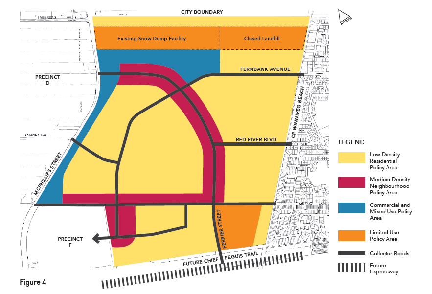
Proposed land uses for Precinct G
Low Density Residential Policy Areas
Suggested Policy Addition
Subdivisions will be designed to allow access to the local cycling network (i.e. pathways and collector roads with an all ages and abilities cycling facility) within 400m of most dwellings and commercial sites via local streets and pathways.
Rationale
We want to stress the need to provide connectivity to the wider range of destinations outlined in our suggested text for Objective 4 through a dense network of bicycle facilities.
Commercial and Mixed Use Policy Areas
Suggested Policy Addition
Commercial and Mixed Use Policy Areas shall be connected to the walking and cycling network.
Rationale
This mirrors the language of policy 3.2.6 of the Medium Density Neighbourhood Policy Areas and is intended to ensure connections are provided to commercial and mixed use policy areas. This addition is in line with recommendations in the Pedestrian and Cycling Strategies to provide connections to mixed use centres and corridors (pg. 137, Pedestrian and Cycling Strategies).
School Sites
Suggested Policy Addition
The Cycling Network shall be designed to provide age appropriate, comfortable links to schools in adjoining neighbourhoods along reasonably direct routes.
Rationale
The neighbourhood will depend to some extent on schools outside of the planning area, and will need to provide quality bicycle routes to schools in adjoining communities to meet its educational needs. As no High School is anticipated in the planning area, this is particularly true of routes to and from high schools outside of the planning area. To be practical, routes to schools outside of the planning area need be direct as possible and to avoid excessive detours.
Transportation
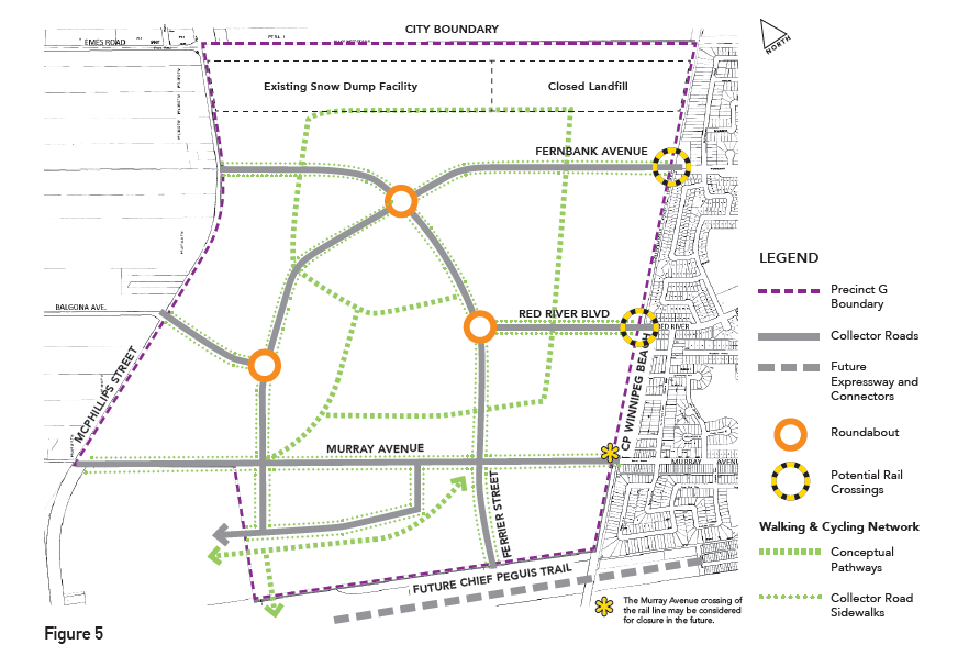
Draft Transportation Network from the Precinct G Draft Master Plan
Road Network
Collector and Arterial Streets
Midblock Crossings
Midblock crossings of pathways shall be integrated with planning of transit stops to help facilitate the desire for most residences in low density areas to have access to public transit within a 400m walking distance of residential dwellings.
Rationale
Midblock crossings will almost certainly be needed to facilitate a dense, well-connected cycling network and to provide access to transit within a 400m walkable distance of most residential dwellings n low density areas, as transit user’s will have to connect to transit routes from both sides of a roadway.
On-Street Bicycle Facilities
Suggested Policy Additions
• Selection of on-street bicycle facility types shall take adjacent land use into account, and shall be geared towards an all ages and abilities facility type.
• Selection of on-street bicycle facilities should take into account connections into adjoining neighbourhoods (existing or planned) to promote smooth transition from new cycling facilities onto existing, planned, or desired cycling facilities and consistency within the overall cycling network.
• Where pathways are selected as the preferred on-street or off road bicycle facility type, to promote consistency pathways shall be built on the same side of the roadway (or on both sides of the roadway) for the entire length of the facility within the precinct.
Rationale
The type of cycling facility selected needs to reflect adjacent land use and eventual connectivity with adjoining neighbourhoods. Transitions from new bicycle facilities planned as part of the Precinct G development need to provide logical transitions to existing and/or planned (or desired/warranted) cycling facilities in adjoining neighbourhoods to ensure the creation of a comfortable cycling network that provides connections to neighbouring and regional destinations.
Local Streets
Suggested Policy Additions
In line with planning for an all ages and abilities cycling network, local streets shall be designed with a design speed of 30km/hr and the local street network should be designed in such a way as to encourage daily traffic volumes of no more than 500 vehicles per day.
Pathway end points will align with existing or planned pathways, low speed, low volume local streets or separated on-street cycling facilities to promote a well-connected, comfortable cycling network.
Rationale
Local streets are the backbone of all walking and cycling networks. To keep them comfortable for mixed use between motorized vehicles and people on bikes, an all ages and abilities local street should aim for a traffic volume of no more than 500 motorized vehicles per day, and an average speed of no more than 30km/hr (City of Vancouver Transportation Design Guidelines: All Ages and Abilities Cycling Networks).
Walking and Cycling Network
Suggested Policy Additions
The cycling network shall provide frequent connections to the pathway along the planned Chief Peguis Trail pathway to promote direct, comfortable access to an important regional pathway in the city’s planned cycling network.
The cycling network shall provide frequent connections to the pathway planned along the east side of McPhillips Street in the Commercial and Mixed Use planning zone .
The cycling network will focus facility type selection on Off-Street Pathways, Protected Bike Lanes, and Neighbourhood Greenways as the most preferred type of facility to ensure that the network is attractive to people of all ages and abilities.
Rationale
Research shows that a bicycle route network with designated routes spaced a minimum of400m apart should be the goal for urban areas (pg. 136).
The Pedestrian and Cycling Strategies propose focusing bicycle facilities on Off-Street Pathways, Protected Bike Lanes, and Neighbourhood Greenways as the most preferred type of facility to ensure that the network is attractive to people of all ages and abilities. (pg. 140, Pedestrian and Cycling Strategies).
Next Stages
From here, the precinct plan will go to the Executive Policy Committee, and if passed there will go before a full vote of city council. If passed there, public hearings before the Lord Selkirk – West Kildonan Community Committee sometime after the fall election.
Further Reading
- Bike Winnipeg Submission (pdf)
- Precinct G Project Site -(Landmark Planning & Design)
- Provides background information and Presentation Boards from past Public Meetings and Open Houses
- PP & D Committee Agenda – Precinct G is Report #30 on the Agenda
- Appendix C: Draft Master Plan
- Appendix D: Recommended Alterations
- Appendix E: Background Material
- Chief Peguis Trail Extension West Study (City of Winnipeg site)
- City of Winnipeg Project Site
- Includes detailed maps of the proposed extension of the Chief Peguis Trail Expressway, and the associated pathways
- Bike Winnipeg Recommendations
- City of Winnipeg Project Site
- Our Winnipeg –Complete Communities (pdf)