[spacer height=”1px”]
To help Council Candidates and Voters better understand cycling policy and infrastructure project priorities, Bike Winnipeg has put together a number of policy and infrastructure recommendations that we hope can be moved forward in the next term of council.
Local Cycling Improvements
The City of Winnipeg’s Pedestrian & Cycling Strategies calls for a dense, connected bicycle network to be developed over the next 20 years that will provide direct routes to key destinations. Included in the strategies is a recommendation to develop a new pedestrian & bicycle crossing of the Red River connecting connecting Scotia Street (near Rupertsland) to Kildonan Drive (Bronx Pl.).
 New Neighbourhood Connections
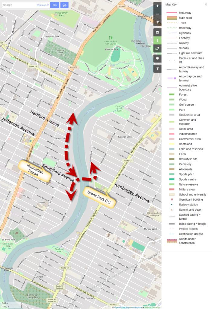
A new Scotia St – Kildonan Dr AT Bridge would provide an important walking and cycling connection across the Red River at a point where access along the east bank of the Red River is restricted to Henderson Highway and beyond. This would create shortened travel distances for people walking or cycling between the Munroe West and Scotia Heights communities, as the nearest bridges are current the Kildonan Settlers Bridge (Chief Peguis Trail) and the Harry Lazarenko Bridge (Redwood). As the Harry Lazeranko Bridge is not a particularly bicycle friendly bridge, in reality, most people riding their bikes are currently choosing between the Kildonan Settlers Bridge and the Disraeli AT Bridge.
New Neighbourhood Connections
A new Scotia St – Kildonan Dr AT Bridge would provide an important walking and cycling connection across the Red River at a point where access along the east bank of the Red River is restricted to Henderson Highway and beyond. This would create shortened travel distances for people walking or cycling between the Munroe West and Scotia Heights communities, as the nearest bridges are current the Kildonan Settlers Bridge (Chief Peguis Trail) and the Harry Lazarenko Bridge (Redwood). As the Harry Lazeranko Bridge is not a particularly bicycle friendly bridge, in reality, most people riding their bikes are currently choosing between the Kildonan Settlers Bridge and the Disraeli AT Bridge.
 Based on estimates developed for the U of M St. Vital Pedestrian & Bicycle Bridge back in October of 2013, we estimate that the cost of construction for a Pedestrian & Bicycle Bridge linking Scotia St to Kildonan Dr would be about $15 million.
Further Reading
City of Winnipeg Pedestrian & Cycling Strategies
Based on estimates developed for the U of M St. Vital Pedestrian & Bicycle Bridge back in October of 2013, we estimate that the cost of construction for a Pedestrian & Bicycle Bridge linking Scotia St to Kildonan Dr would be about $15 million.
Further Reading
City of Winnipeg Pedestrian & Cycling Strategies
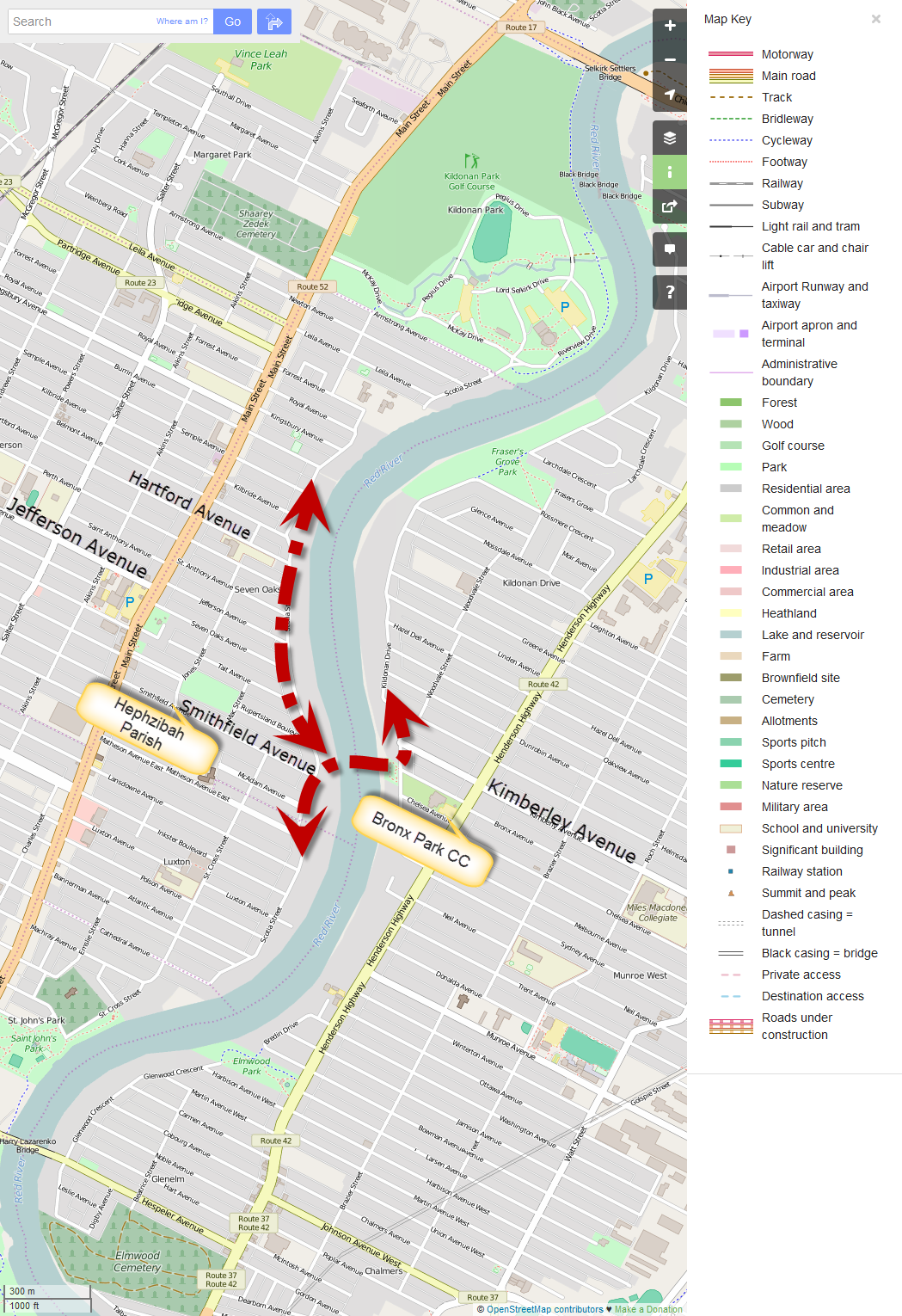
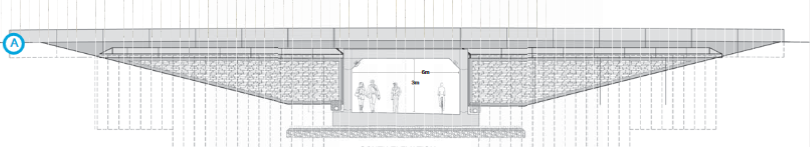
Suggested location of Scotia St – Kildonan Dr AT Bridge (map courtesy OpenStreetMaps.org)
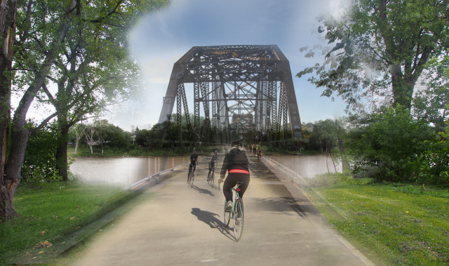
Mock up of Scotia St – Kildonan Dr Pedestrian & Bicycle Bridge
A major rehabilitation of the Lagimodiere Twin Bridges (Concordia and CPR Keewatin) will provide the city with an opportunity to carry through on one of the crossing improvements identified in the Pedestrian and Cycling Strategies[1].
A Through-Pass at the southern end of the Lagimodiere Twin Bridges would provide a connection between:
- West of Lagimodiere
- Molson/Panet Bike Lanes
- CPR Keewatin Rail with Trail (planned)
- Kimbeley/Concordia Bikeway (planned)
- East of Lagimodiere
- CPR Keewatin Rail with Trail (planned)
- Peguis St Pathway
- Ravelstone/Transcona Blvd Bike Lanes (planned)
A Through-Pass similar to the one begin built as part of the Fermor Ave Seine River Bridge should be included in the Lagimodiere Twin Bridges Rehabilitation Project.
Options for a through-pass at Lagimodiere include a new through-pass along the Ravelstone right of way, similar to what is being done with the Fermor Ave Seine River Bridge rehabilitation project, or a pathway under the CPR Keewatin Bridge similar to what was built along the Bishop Grandin Greenway beneath the CN Letellier rail line.
Summary of Recommendations
We are asking candidates to commit to the inclusion of a Walk/Bike Though-Pass in the Lagimodiere Twin Bridges Rehabilitation Project.
More Information
- Lagimodiere Twin Bridges Project Site (City of Winnipeg)
- Fermor Avenue Bridge Over Seine River Rehabilitation and Roadworks (City of Winnipeg)
Footnotes
[1]Pages 178-179, Pedestrian and Cycling Strategies, City of Winnipeg, 2015
The Trasncona Trail was one of the biggest projects included in the 2010 Federal Stimulus Fund Package. It runs 6.7km from the Perimeter Highway across the northern limit of Transcona before veering southwest to follow the CEMR rail line to Regent Ave, where it ends.
This leaves people with the choice of continuing their ride along Regent Ave and its six plus lanes of traffic, or turning around and heading back to wherever they cam from. Not many choose to continue down Regent Ave. The lack of any safe, direct connection between the southern end of the Transcona Trail and St. Boniface is one of the biggest barriers to cycling in the city.
Thankfully, plans are in the works to close this gap in the city’s bike network.
Plans to extend the Transcona Trail south across Regent Ave to Panet Rd will make a huge difference for people biking into or out of Transcona while providing much needed access to shopping within Transcona.
Trancona Trail Extension to Provide Safe Crossings of Regent and Lagimodiere
The Transcona Trail Extension Project will construct a multi-use path to extend the Transcona Trail from its existing termination at Regent Avenue West to Panet Road. The design will include a crossing connection at Regent Avenue to access the path extension.
This project was approved for multiple year funding in the 2017 Pedestrian and Cycling Program of the Capital Budget. A preliminary study was completed in 2016 and more detailed design work is taking place throughout 2017, which includes land negotiations.
From Panet Road, it is hoped that the pathway would connect up with an all ages and abilities bikeway to be built as part of the Eastern Rapid Transit Corridor. The Eastern Corridor Study, currently underway, aims to determine routing for the Eastern Rapid Transit Corridor and Pathways.
In the meantime, the most likely connection from Panet Road to the Downtown is via Mission St and Notre Dame St to Tache Ave and the Esplanade Riel Walk/Bike Bridge into The Forks. To facilitate the connection to MIssion St, we are recommending that the city include a pathway connection from the planned western terminus of the pathway at Panet Road to Mission St. The city has an easement for a pathway along the eastern side of Panet Road for just this purpose, so an extension of the pathway south to Mission St should be a fairly simple addition to any construction contract.
Key Candidate Commitments
- Commit to Completion of the Transcona Trail Extension Project as currently planned in 2019
- Commit to an Extension of the planned Transcona Trail Extension south to Mission St. along the east side of Panet Rd through an existing easement.
More Information
Transcona Trail Extension Project (City of Winnipeg)
Eastern Corridor Study (City of Winnipeg)
Posted in 2018 Election Backgrounder
Tagged 2018 Winnipeg El, Elmwood-East Kildonan, st. boniface, Transcona
3 Comments
Ward Boundaries: Legal Description Map